Ride Joburg: Here are the affected roads and alternative routes
Chante Ho Hip
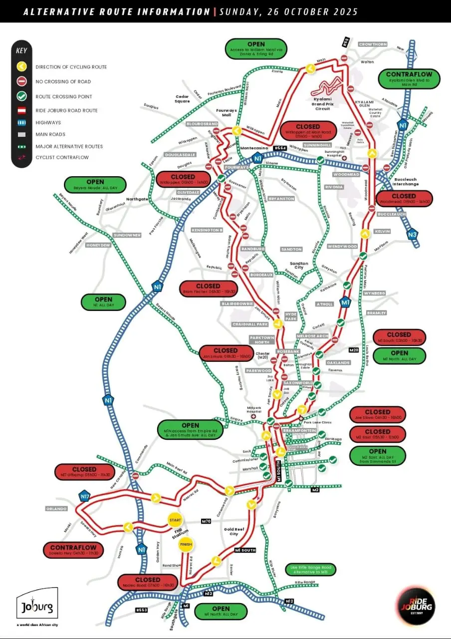
26 October 2025 | 9:25Several major roads from Johannesburg South to Midrand will be affected by the Ride Joburg cycle race on Sunday, 26 October.

Photo: Unsplash/john_cameron
Cyclists from across the country will take to the streets of Johannesburg this weekend for the annual Joburg cycle race.
Over 20,000 riders are expected on the streets on Sunday, 26 October.
RELATED: Ride Joburg returns: Former winner shares advice to get you ready
If you are not taking part, plan your route for the day accordingly, as several major roads from Johannesburg South to Midrand will be closed from as early as 3am on race day.
The City of Johannesburg, Gauteng Traffic Patrol, and JMPD will be out on the streets to ensure everyone's safety.
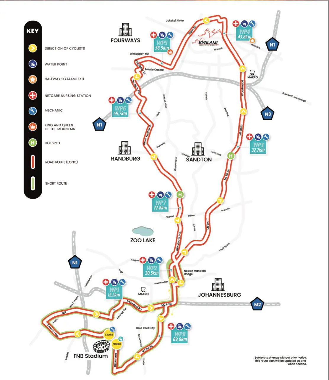
The following roads will be affected:
- Rand Show Road between Nasrec Road and the N1 Highway
- Nasrec Road between the N17 circle to Booysens Reserve Road
- Soweto Highway between Nasrec Road and the N17 (Klipspruit Valley)
- Booysens Reserve Road between Nasrec Road and Amethyst Road
- N1 West off-ramp to the N17
- N17 from the M70 (Klipspruit Valley Road) to N1 North on-ramp
- N17 West to the N1 North on-ramp
- Nasrec Road between the N17 circle (Riverlea) to Main Reef Road
- Main Reef Road between Nasrec Road and Hanover Street
- M2 East between Nasrec Road and Eloff Street
- M1 North and M2 West at the M1 North off-ramp
- M1 South between Buccleuch Interchange to Columbine Avenue
- Woodmead Drive/R55 at off-ramp on M1 North
- Woodmead Drive/R55 between Woodlands Drive to Maxwell Drive (World of Golf)
- Woodmead Drive/R55 between Maxwell Drive to Allandale Road
- Woodmead Drive/R55 between Shakespeare Road and Dytchley Road
- R55/Pitts Avenue between Kyalami Glen Boulevard to Allandale Road to Main Road
- Begonia Road between R55/Pitts Avenue to Main Road
- Hawthrone Road between Begonia Road and Main Road
- Main Road between R55/Pitts Avenue to Zinnia Road
- Main Road between Zinnia Road to Witkoppen Road
- Witkoppen Road between Main Road and Kingfisher Drive
- Kingfisher Drive into Alexander Avenue
- Alexander Avenue into Westway Road
- Westway Road into Leslie Road
- Leslie Road into Douglas Road
- Douglas Road into Grosvenor Road
- Grosvenor Road to Moray Drive
- Grosvenor to Moray Drive to Cumberland Avenue
- Cumberland Avenue between Moray Drive and Homestead Avenue
- Homestead Avenue between Cumberland Avenue and Bram Fischer Drive
- Bram Fisher Drive between Homestead Avenue and Jan Smuts Avenue
- Jan Smuts Avenue between Bram Fisher Drive to Empire Road
- Jan Smuts Avenue/Bertha Street between Ntemi Piliso Street to Miriam Makeba Street
- Carr Street between Ntemi Piliso Street to Miriam Makeba Street
- Nasrec Road between Rifle Range Road and Adcock Ingram Avenue
- Nasrec Road between Adcock Ingram Avenue to Rand Show Road
The following alternative routes can be utilised in the affected areas:
- M1N access from Empire Road and Jan Smuts Avenue
- M1N
- M2E from Simmonds Street
- Rifle Range Road
- Rivonia Road
- Oxford Road
- Old Pretoria Main Road
- Louis Botha Avenue
For the full map breakdown, visit the Ride Joburg website here.
Get the whole picture 💡
Take a look at the topic timeline for all related articles.
